Showing posts with label Uttar Pradesh. Show all posts

Thursday, April 7, 2011

Chhota Imambara


Chhota Imambara (छोटा इमामबाड़ा), also known as Hussainabad Imambara is an imposing monument located in the city of Lucknow, Uttar Pradesh, India. Built by Muhammad Ali Shah, The third Nawab of Avadh in 1838, it was to serve as his own mausoleum. It is also known as the Palace of Lights because of its decorations during special festivals.
The chandeliers used to decorate the interior of this building was brought from Belgium. Thousands of labourers worked on the project to gain famine relief.
It has a gilded white dome and several turrets and minarets. The tombs of Muhammad Ali Shah and other members of his family are inside the imambara. The walls are decorated with Arabic calligraphy.
Outside the imambara is the watch tower called Satkhanda or tower of seven storeys. Though it is called satkhanda, it has only four storeys, as the construction of the tower was abandoned when Ali Shah died. satkhanda is built between 1837-1842 in the time of mohammad ali shah. mohammad ali shah wanted to made it same as kutubmeenaar of delhi and leaning tower of pisa.the main purpose of this construction is moon watching.

Bara Imambara


Bara Imambara

Bara Imambara (बड़ा इमामबाड़ा) is an imambara complex in Lucknow, India, built by Asaf-ud-daulah, Nawab of Lucknow, in 1784. It is also called the Asafi Imambara.
Bara means big, and an imambara is a shrine built by Shia Muslims for the purpose of Azadari. The Bara Imambara is among the grandest buildings of Lucknow.
The complex also includes the large Asfi mosque, the bhulbhulayah (the labyrinth), and bowli, a step well with running water. Two imposing gateways lead to the main hall.

The Bara Imambara was built in 1783, a year of a devastating famine, and one of Asaf-ud-Daula's objectives in embarking on this grandiose project was to provide employment for people in the region. According to reports, the famine continued for over a decade and the construction of the building continued for this time. It is said that ordinary people used to work in the day building up the edifice, while noblemen and other elite were called at night to break down all the structure raised, as they were incapable of doing anything else, according to a chronicle of the period. This see-saw efforts continued till the famine period was over. It was a project that preceded a Keynesian like intervention for employment generation.

The architecture of the complex reflects the maturation of ornamented Mughal design, namely the Badshahi Mosque - it is one of the last major projects not incorporating any European elements or the use of iron. The main imambara consists of a large vaulted central chamber containing the tomb of Asaf-ud-Daula. At 50 by 16 meters and over 15 meters tall, it has no beams supporting the ceiling, and is one of the largest such arched constructions in the world. There are eight surrounding chambers built to different roof heights, permitting the space above these to be reconstructed as a three-dimensional labyrinth with passages interconnecting with each other through 489 identical doorways. This part of the building, known as a popular attraction, and often the whole complex may be referred to as the bhulbhulayah. It is possibly the only existing maze in India and came about unintenionally to support the weight of the building, constructed on marshy land. Asaf-ud-Daula also erected the 18-m (59-f high Rumi Darwaza, just outside. This portal, embellished with lavish decorations, was the Imambara's west facing entrance. 
The design of the Imambara was obtained through a competitive process. The winner was an architect Kifayatullah, who also lies buried in the main hall of the Imambara. It is another unique aspect of the building where the sponsor and the architect lie buried besides each other.
There is also a blocked (tunnel) passageway which, according to legends, leads through a mile-long underground passage to a location near the Gomti river. Other passages are rumoured to lead to Faizabad (the former seat of power of the Nawabs), Allahabad and even to Delhi. They exist but have been sealed after a period of long disuse as well as fears over the disappearance of people who had purportedly gone missing, while exploring.


Thursday, March 31, 2011

Taj Mahal


The Taj Mahal is a mausoleum located in Agra, India. It is one of the most recognizable structures in the world. It was built by Mughal emperor Shah Jahan in memory of his third wife, Mumtaz Mahal. It is widely considered as one of the most beautiful buildings in the world and stands as a symbol of eternal love.
Taj Mahal is the finest example of Mughal architecture, a style that combines elements from Persian, Islamic and Indian architectural styles.
In 1983, the Taj Mahal became a UNESCO World Heritage Site. While the white domed marble mausoleum is the most familiar component of the Taj Mahal, it is actually an integrated complex of structures. The construction began around 1632 and was completed around 1653, employing thousands of artisans and craftsmen. The construction of the Taj Mahal was entrusted to a board of architects under imperial supervision, including Abd ul-Karim Ma'mur Khan, Makramat Khan, and Ustad Ahmad Lahauri. Lahauri is generally considered to be the principal designer.

Origin and inspiration

In 1631, Shah Jahan, emperor during the Mughal empire's period of greatest prosperity, was grief-stricken when his third wife, Mumtaz Mahal, died during the birth of their 14th child, Gauhara Begum. Construction of the Taj Mahal began in 1632, one year after her death. The court chronicles of Shah Jahan's grief illustrate the love story traditionally held as an inspiration for Taj Mahal. The principal mausoleum was completed in 1648 and the surrounding buildings and garden were finished five years later. Emperor Shah Jahan himself described the Taj in these words:
Should guilty seek asylum here,
Like one pardoned, he becomes free from sin.
Should a sinner make his way to this mansion,
All his past sins are to be washed away.
The sight of this mansion creates sorrowing sighs;
And the sun and the moon shed tears from their eyes.
In this world this edifice has been made;
To display thereby the creator's glory.
The Taj Mahal incorporates and expands on design traditions of Persian architecture and earlier Mughal architecture. Specific inspiration came from successful Timurid and Mughal buildings including; the Gur-e Amir (the tomb of Timur, progenitor of the Mughal dynasty, in Samarkand), Humayun's Tomb, Itmad-Ud-Daulah's Tomb (sometimes called the Baby Taj), and Shah Jahan's own Jama Masjid in Delhi. While earlier Mughal buildings were primarily constructed of red sandstone, Shah Jahan promoted the use of white marble inlaid with semi-precious stones, and buildings under his patronage reached new levels of refinement.

Wednesday, May 12, 2010

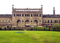
History of Lucknow

After 1350 AD the Lucknow and parts of Awadh region have been under the rule of the Delhi Sultanate, the Mughal Empire, the Nawabs of Awadh, the East India Company and the British Raj. Lucknow has been one of the major centers of First War of Independence, participated actively in India's Independence movement, and after Independence has emerged as an important city of North India.

Until 1719, subah of Awadh was a province of the Mughal Empire administered by a Governor appointed by the Emperor. Saadat Khan also called Burhan-ul-Mulk a Persian adventurer was appointed the Nazim of Awadh in 1722 and he established his court in Faizabad near Lucknow.

Awadh was known as the granary of India and was important strategically for the control of the Doab, the fertile plain between the Ganga and the Yamuna rivers. It was a wealthy kingdom, able to maintain its independence against threats from the Marathas, the British and the Afghans. The third Nawab,Shuja-ud-Daula fell out with the British after aiding Mir Qasim, the fugitive Nawab of Bengal. He was comprehensively defeated in the Battle of Buxar by the East India Company, after which he was forced to pay heavy penalties and cede parts of his territory. The British appointed a resident in 1773, and over time gained control of more territory and authority in the state. They were disinclined to capture Awadh outright, because that would bring them face to face with the Marathas and the remnants of the Mughal Empire.
Lucknow's rise to growth and fame begins with its elevation as capital of Awadh by Nawab Asaf-Ud-Dowlah. He was a great philanthropist and gave Lucknow a unique and enduring legacy. The architectural contributions of these Awadh rulers include several imposing monuments. Of the monuments standing today, the Bara Imambara, the Chhota Imambara, and the Roomi Darwaza are notable examples. One of the more lasting contributions by the Nawabs is the syncretic composite culture that has come to be known as theGanga-Jamuni tehzeeb.

In 1798, the fifth Nawab Wazir Ali Khan alienated both his people and the British, and was forced to abdicate. The British then helped Saadat Ali Khan to the throne. Saadat Ali Khan was a puppet king, who in the treaty of 1801 ceded half of Awadh to the British East India Company and also agreed to disband his troops in favor of a hugely expensive, British-run army. This treaty effectively made the state of Awadh a vassal to the British East India Company, though it notionally continued to be part of the Mughal Empire in name until 1819.

The treaty of 1801 formed an arrangement that was very beneficial to the Company. They were able to use Awadh's vast treasuries, repeatedly digging into them for loans at reduced rates. In addition, the revenues from running Awadh's armed forces brought them useful revenues while it acted as a buffer state. The Nawabs were ceremonial kings, busy with pomp and show but with little influence over matters of state. By the mid-nineteenth century, however, the British had grown impatient with the arrangement and wanted direct control of Awadh.

In 1856 the East India Company first moved its troops to the border, then annexed the state, which was placed under a chief commissioner - Sir Henry Lawrence. Wajid Ali Shah, the then Nawab, was imprisoned, and then exiled by the Company to Calcutta. In the subsequent Revolt of 1857his 14-year old son Birjis Qadra son of Begum Hazrat Mahal was crowned ruler, and Sir Henry Lawrence killed in the hostilities. Following the rebellion's defeat, Begum Hazrat Mahal and other rebel leaders obtained asylum in Nepal.
Those company troops who were recruited from the state, along with some of the nobility of the state, were major players in the events of 1857. The rebels took control of Awadh, and it took the British 18 months to reconquer the region, months which included the famous Siege of Lucknow. Oudh was placed back under a chief commissioner, and was governed as a British province. In 1877 the offices of lieutenant-governor of the North-Western Provinces and chief commissioner of Oudh were combined in the same person; and in 1902, when the new name of United Provinces of Agra and Oudh was introduced, the title of chief commissioner was dropped, though Oudh still retained some marks of its former independence.

The province of Awadh was annexed by the East India Company in 1856 and placed under the control of a chief commissioner. In the Indian Rebellion of 1857 (also known as the First War of Indian Independence and the Indian Mutiny), the garrisonbased at the Residency in Lucknow was besieged by rebel forces. The famous Siege of Lucknow was relieved first by forces under the command of Sir Henry Havelock and Sir James Outram, followed by a stronger force under Sir Colin Campbell. Today, the ruins of the Residency, and the picturesque Shaheed Smarak offer reminiscences of Lucknow's role in the stirring events of 1857.

The city played an important role in both the First War of Independence and the modern Indian freedom struggle. Whether it was theLucknow Pact of 1916 or the Khilafat Movement, it brought the citizens on a united platform against the British rule. In the Khilafat Movement Maulana Abdul Bari of Firangi Mahal, Lucknow actively participated and cooperated with Mahatama Gandhi and Maulana Mohammad Ali.

In 1901, after remaining the capital of Oudh since 1775, Lucknow, with a population of 264,049, was merged in the newly formed United Provinces of Agra and Oudh.[18] However, it became the provincial capital in 1920 when the seat of government was moved from Allahabad. Upon Indian independence in 1947, Lucknow became the capital of Uttar Pradesh, the erstwhile United Provinces.

Tuesday, May 11, 2010

Kanpur

Kanpur spelled as Cawnpore before 1948, is the ninth most populous city in India and the largest nestled on the banks of the river Ganga, Kanpur stands as one of North India’s major industrial centres with its own historical, religious and commercial importance. It is believed to have been founded by Hindu Chandel King of the state of Sachendi. The city's name is believed to have been derived from Kanhiyapur, the town of Kanhiya (Lord Krishna). In the course of time, Kanhiyapur probably was abbreviated as Kanhapur and subsequently as Kanpur. "Cawnpore" was the Anglicized spelling of the name during the British Raj.

Others believe that the name is derived from Karnapur and is associated with Karna, one of the heroes of the Mahabharata. Duryodhana made Karna a king, seeing him as a fitting match to Arjuna, and granted him this area; the region was named after its first king. Another theory is that it came from the nearby town of Makanpur, earlier known as Khairabad, where the Sufi saint of the Madariya Sufi order, Badiuddin Zinda Shah Madar (d. 1434 CE), settled. [4] Historically, Jajmau, on the eastern outskirts of present day Kanpur, is regarded as one of the original settlements in the Kanpur district.

Kanpur's development is unclear until the 13th century. Although no reference to Kanpur is found in history, the history of two of its suburbs, Jajmau and Bithoor, can be traced back to legendary times. Bithoor is located about 20 km upstream from the city and is approximately 10 km from the IIT Kanpur Campus. Jajmau is about 8 km east of Kanpur city and is nearly 20 km downstream from the IIT Campus. According to Hindu mythology, just after creating the universe, Lord Brahma performed the Ashvamedh Yajna (a horse is released and escorted by armies, which engaged in battle anyone who impeded the horse's progress) at Bithoor (also known as Brahmavart) and established a shivalingam there. Another legendary site at Bithoor is the ValmikiAshram, where the famous sage Valmiki is supposed to have written the Sanskrit epic, theRamayana. According to this epic, queen Seeta, on being exiled by King Ramachandra ofAyodhya, spent her days in seclusion at the ashram bringing up her twin sons, Lava and Kush.

At Jajmau there are remains of an ancient fort, now surviving as a huge mound. Recent excavations on this mound indicate that the site is very ancient, perhaps dating back to the Vedic age. Popular legends[which?] state that the fort belonged to Yayati, a king of the ancient Chandravanshi race, the eighth in succession to Lord Brahma. The famous Siddhnath temple of Lord Shiva and the Siddha Devi temple at Jajmau belong to the Buddhist period. The place was once known as Siddhpuri.

At Shivrajpur, 20 km from the Kanpur Central Railway Station, there is an ancient temple built by Chandel Raja Sati Prasad in memory of his queen. This temple is supposed to have been built in a night and is situated on the banks of river Ganga. This temple is famous for its beautiful architectural work and its unique carving designs.

Gurjar Parihar rulers of Kannauj may have ruled this place for a significant part of history long before the beginning of Mughal era. Some historical accounts suggest Gurjara Pratihara emperor, Mihir Bhoja, has ruled in Kanpur since nearby Kannuaj was the capital of Gurjar Parihar.[5]

In 1207 AD, Raja Kanti Deo of Prayag (connected to the throne of Kannauj) established the village Kohna, which later came to be known as Kanpur. Kanpur continued its association with Kannauj during the reigns of Harsha Vardhan, Mihir Bhoja, Jai Chand and early Muslim rulers through the Sur Dynasty. The first mention of Kanpur was made in 1579 during Sher Shah's regime. Up to the first half of the 18th century, Kanpur continued to survive as an insignificant village. Its fate, however, took a new turn in the second half of the 18th century. In May 1765, Shuja-ud-daula, the Nawab Wazir of Awadh, was defeated by the British near Jajmau. From 1773 to 1801, it was part of the Oudh kingdom and then came into the hands of the British. At this time, the British realized the strategic importance of the site of Kanpur. European businessmen had, by this time, started establishing themselves in Kanpur. In order to ensure protection for their lives and property, the European business shifted the `Awadh local forces’ here in 1778. Kanpur passed into British hands under the treaty of 1801 with Nawab Saadat Ali Khan of Awadh. This forms a turning point in the history of Kanpur, as it became one of the most important military stations of British India. It was declared a district on 24 March 1803. South of Parmat were the British infantry lines and the parade grounds. Indian infantry occupied the space from the present Chunniganj to the Christ Church College. The Company Bagh was laid in 1847 and the construction of the Ganga canal was completed in 1854. within the state of Uttar Pradesh. It is the second largest city of the Hindi speaking belt after Delhi. It was formerly known as the "Manchester of the East", and remains one of the oldest industrial townships of North India, although it has not kept pace with industrial growth in the rest of India. It has an area of over 1300 km² and a population of 4,864,674 which is estimated to grow upto 6 million by 2011. Owing to the city's industrial importance, one of the few branches of the Reserve Banks of India and Institute of Chartered Accountants of India were established in the city. It is also home to several globally recognized institutions such as IIT Kanpur, Harcourt Butler Technological Institute (HBTI) and GSVM Medical College. The status of the city was upgraded when it was included in the "Counter Magnets" of National Capital Region (NCR).

Unnao

The freedom struggle of 1857-1858 was followed by the transfer of power from the East India Company to the British Crown. As soon as order had been restored, the civil administration was re-established in the district which was named district Unnao, with headquarters at Unnao. The size of the district was however small till 1869, when it assumed its present form. The same year the town of Unnao was constituted a Municipality.

In ancient times the area covered by the present district of Unnao formed part of the region known as Kosala and was later included in the Subha of Awadh or simply Awadh. This tract appears to have seen civilized and settled life since very early times. Finds from and traces of ancient remains at several places in the district are however, fairly interesting and testify to the antiquity of those sites.

Hiuen Tsang, the famous chinese pilgrim to India, stayed at Kannauj for 3 months in 636 AD. From here he journeyed a distance of about 26 kms and reached the city of Na-fo-ti-po-ku-lo (Navadevakula) which stood on the eastern bank of Ganga. The city was about 5 km in circumference and had in or about it, a magnificent Deva Temple, several Buddhist Monasteries and Stupas. This place, which is about 3 kms north-west of Bangarmau in Tehsil Safipur, has been identified by some scholars with Nawal and is supposed to represent the site of an important ancient city, believed to have been upturned in the 13th century by the curse of a saint, and still called Aundha Khera or Lauta Shahr both meaning an upturned city. The dargah of the Muslim saint, whose curse is said to have befallen the city, is not only the oldest Muslim monument at Bangarmau but perhaps, in the entire district.

By far the most important ancient site in the district is perhaps Sanchankot, also known as Sujankot, which lies in village Ramkot, in pargana Bangarmau of Tehsil Safipur about 55 km north-west of Unnao.

History of District as Administrative Unit

In the days of Akbar, the tract covered by the district was included in sirkar Lucknow of the province of Avadh, and the mahals of his time appear generally speaking, to have been close predecessors of the parganas of today.

During the days of nawabs of Avadh, the eastern portion of the district formed the chaklaof Purwa. The portion of the district lying to the north of this chakla were included in the chaklas of Rasulabad and Safipur which also included the mahal of Mohan. Pargana Auras belonged to the chakla of Sandila belonging to district Hardoi. The tract comprised in Pargana Patan, Panhan, Bihar, Bhagwantnagar, Magaryar, Ghatampur and Daundia Khera formed part of the chakla of Baiswara.

After the annexation of Awadh by the British in February 1856, the district, then called district Purwa came into existence and the headquarter was shifted from Purwa to Unnao. The district then contained 13 parganas namely Bangarmau, Fatehpur Chaurasi, Safipur, Pariar, Sikandarpur, Unnao, Harha, Asiwan-Rasulabad, Jhalotar-Ajgain,Gorinda Parsandan, Purwa, Asoha and Mauranwan. In 1869, parganas Panhan Patan, Bihar, Bhagwantnagar, Magaryar, Ghatampur and Daundia khera were transferred from district Rae Bareli to tehsil Purwa of this district, and pargana Auras-Mohan was transferred from district Lucknow to the old tehsil Nawabganj of this district . Whence the tehsil headquarters were removed first to Mohan and, again in 1891, to Hasanganj.